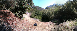
I'm busy doing some things other than blogging. One of the fun things I'm doing is familiarizing myself with local trails. It turns out there are plenty of obscure and undocumented ones, such as the "Mailbox Trail" which quickly devolves into a single track along the edge of George F Canyon.
George F turns into another canyon system further along, and the trails are wide and well maintained in this area (for horses).
That's Toyon (Heteromeles arbutifolia) on the left with the red berries and Lemonade Berry (Rhus integrifolia) looming over the right hand branch of the trail. They're easy to tell apart this time of year with the red berries only on Toyon, which is also known as Christmas Berry. When they are not in bloom, I think the easiest way to tell them apart is by the leaf edges: Serrations on the Toyon, smooth or wavy on Lemonade Berry. This seems to be locally true, anyway.
I have been assured that all trails are public access, yet already I've run into what appear to be bogus trail closings promulgated by local homeowner groups (thinks to self, "Hmm. I don't see the advertised trail hazard that motivated trail closure with not one but two chain link fences across the trail. Curious - these fences seem designed to cut off down-trail access into a gated community that is advertised as open at the public-access trailhead. Wow, even the horsemen passing within eyeshot of the trail closure don't seem to think there's a hazard.")
I sense some advocacy in my future. Until then, I'm just a quiet trails anthropologist and I'll keep a photo record documenting trail conditions without trying to perturb the system.
I'll be back in a bit to tell you more about native plants - I have tremendous plans for my new yard. Until then, I'm a bit busy. See you on the trails.


Have you checked out the Chandler trails? Some of them are pretty obscure, but if you persist, you can get pretty good views to the north. Sad to say, the map at http://www.pvplc.org/_lands/docs/ChandlerTrailMap2011.pdf is fuzzy. Access is from PV Drive North, east of Rolling Hills Road. Turn in at the Little League/ Dapplegray Elementary, but make an immediate left parallel to the bridle path. The steep, narrow road winds around a hill before arriving at the Little League field; park and continue to the far end of the lot. There is a trail map posted there. For the best view, take the loop on the north side of the golf course. Not many people go on that loop.
ReplyDeleteThanks for the suggestion, Karen! I've been to the Chandler Preserve a couple times recently and I want to go back soon. And you're right: That online map of the preserve stinks.
ReplyDeleteBut I have to say that so far I've enjoyed the hike to the Preserve more than the actual hiking in the Preserve. That will probably change when the Preserve is better restored. What I found right now, however, is that if you take the right approach you wind through interesting ranchette backyards on the bridle paths - people keep all manner of fun animals: geese, chickens, mules, and of course horses. Pristine nature it is not, but it's still a fun, semi-rural, environment.